11.2 Road 1815 Cattle Dip Vat Site, Ozark National Forest, Arkansas
Contact: Lisa Alcorn
Organization: USDA Forest Service
Email: [email protected]
11.2.1 Site Description and Conceptual Site Model
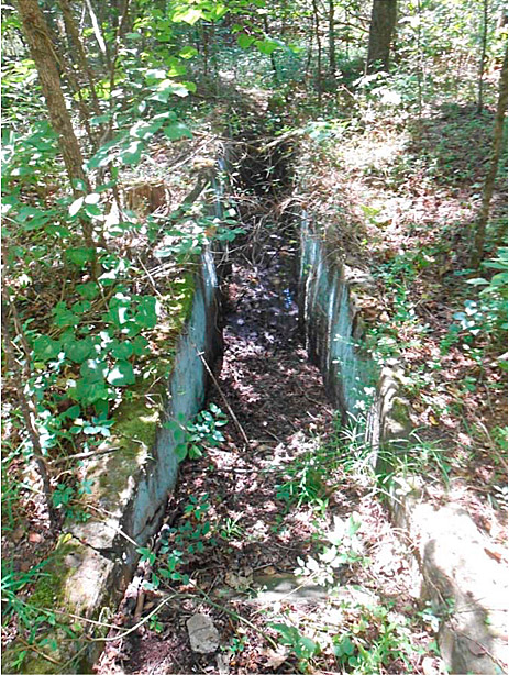
The Road 1815 Cattle Dip Vat (CDV) site is located on the toe slope of a large hill just outside the floodplain associated with the North Fork of the Illinois Bayou. The site is located within the Ozark National Forest and is on federally owned land. The concrete vat structure is approximately 31 feet long by 3.5 feet wide by 4 feet deep and is located adjacent to Forest Road 1815, between the road and Sherman Cemetery. Figure 11-4 shows the Road 1815 Dip Vat.

Figure 11‑4. Road 1815 Dip Vat, Ozark National Forest
Source: L. Alcorn.
Former CDV sites have been identified within Forest Service (FS) Southern Region’s National Forests, which are designated for recreational use and commercial logging. Typically, no fences are present to limit public access to the potentially contaminated former CDV sites. CDV sites within the Southern Region National Forests are generally similar in size and construction and may have been used from approximately 1900 to 1960 for the treatment of livestock. CDVs were typically concrete- or wood-lined basins constructed in pastures or cattle-loading areas that were filled with pesticides. Arsenic-based pesticide solutions were used in conjunction with dip vats and became well established as the preferred method for cattle treatment. Individual cattle were driven into the CDV, where they were immersed in the pesticide solution before exiting the basin at the opposite end onto a drip pad. The identified historical CDV sites are now abandoned and may pose human health and environmental risks due to residual concentrations of metals and pesticides potentially present in environmental media at the sites.
In general, many of these CDV sites are similar in their setting, design and construction, types of chemicals used, and extent of contamination. Investigation of numerous CDV sites across the Southeast has frequently found arsenic in soils. The CDV Management Plan (CDVMP) was implemented to systematically assess the presence, extent, and potential risk posed by residual contamination at CDV sites within the FS Southern Region’s National Forests.
Between 1906 and 1943, CDVs were constructed throughout the southern United States as part of the Cattle Fever Tick (Boophilus microplus and B. annulatus) Eradication Program. The program was aimed at the eradication of the tick responsible for transmitting the ‘Texas Fever’ disease (bovine babesiosis) among cattle herds. After a 36-year campaign, cattle fever ticks were declared eradicated from the United States in 1943; however, dipping reportedly persisted in some areas until the 1960s.
11.2.1.1 Arsenic on the Site
11.2.1.2 Soil Type
11.2.1.3 Source of Arsenic
11.2.1.4 Land Use/Exposure Scenarios
11.2.2 Methodology Used for Evaluating Bioavailability
11.2.2.1 In Vitro Analysis
11.2.3 Calculated Bioavailability of Arsenic in Soils
11.2.4 Application of Bioavailability to Risk Assessment
11.2.5 How Did Bioavailability Results Affect Site Decisions?
11.2.6 Regulatory and Community Considerations


